Third of three posts: Read my parameters and questions and Concept Part 1 route for Seattle to Vancouver via train, then Vancouver to Dayton by bicycle, for context.
As I noted at the end of Tour Concept Part 1, when we get to Dayton we have a decision to make. We can continue more or less directly eastward towards the Idaho border. This will mean climbing the old Spiral Highway, which carries many childhood memories of getting carsick going either up or down because I was born in Lewiston and siblings went to University of Idaho. We can instead head into the Channeled Scablands and visit Palouse Falls State Park, which is supposed to be quite striking. We can do a bit of a mix of Palouse Country and the Scablands.
Any of these routes involves hot, dry, long rides with few services, really small towns and limited choices. Yet another option would be to head back west from Dayton. It’s 58 miles to Tri-Cities and we can take Amtrak back to Seattle from there. However, my original intention in trying to map this out was to end up in Spokane so we can visit friends and family at the end.
In addition, ever since we moved to Seattle eight years ago for me to take a job in professional bike advocacy I regularly encounter some witty person in Spokane who notes that I’m back for a visit and asks, chortling, “Did you ride here?” If we do some version of this tour I could at long last say triumphantly, “YES I DID.” On the other hand, other roads and trails connect Seattle and Spokane. This isn’t my only option.
Format: The day’s start/end points are in boldface. I’ve included some notes about stops along the way for caffeine, food notes if options are limited, and sightseeing, with their mileage from the starting point in that segment. I’m also noting constraints like “only one place to stay”. In some places I break off into a couple of alternate routes to weigh the options. I indicate altitude gain, not descent; the downhill “wheeee” doesn’t need to be part of my endurance calculation but the climbs do.
These are deliberately not numbered as Day 1, Day 2, and so forth. Once I lay this all out I might change some of the break points. For example, I might put together two chunks to create a longer day followed by a shorter day depending on how the combination of eating, sleeping, and slogging up hills comes together.
Option 1: Dayton – Pomeroy – Uniontown – Palouse – Tekoa or Rockford – Spokane, picking up some of the recommendations from the Cycling Sojourner chapter “Pedaling the Palouse”.
- Dayton to Pomeroy, 27 miles, +1249 feet; short mileage day but it’s simply too far to push to another place with lodgings.
- Lodgings: Maggie’s Garden B&B
- Food: Only a couple of cafe options
- Attractions: Pomeroy is a very small town. Garfield County Museum, Meyer’s Fine and Unique Merchandise hardware/gift store, city park and municipal swimming pool to cool off in.

- Pomeroy to Uniontown: 49 miles, +3186 feet
- Clarkston, 30 miles: Lunch, stock up for dinner
- Uniontown, 49 miles: Overnight
- Lodgings: Churchyard Inn is the only option; given that the description includes a complimentary bottle of wine in the room this does not seem like a problem
- Food: Jacobs Bakery & Restaurant (which appears to be in the location of the former Sage Baking Company) is the only breakfast/lunch option. No dinner restaurants so we need to stock up in Clarkston.
- Attractions: Another very small town. One antique store and the art space at the Dahmen Barn, with its fence of old wagon wheels. I’ve driven by this place so many times over the years without stopping once; being on a bike means we won’t be flying by at highway speeds so this would be the time.

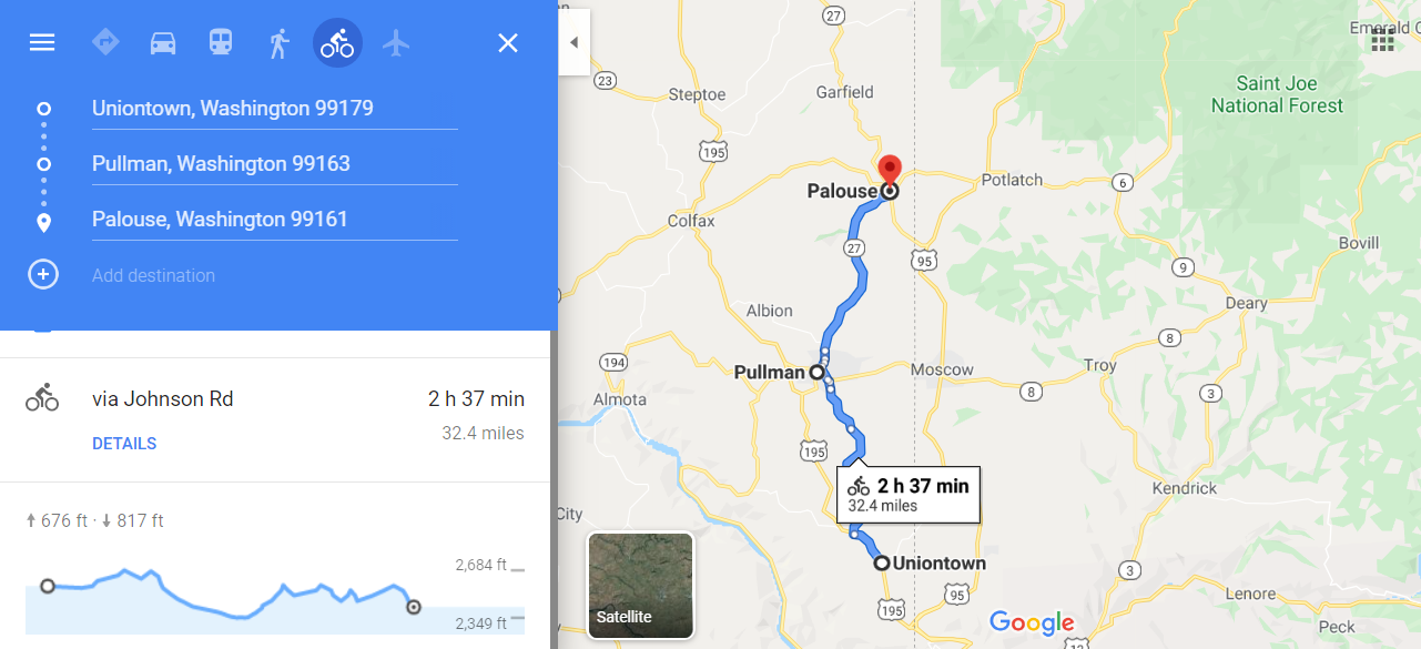
- Uniontown to Palouse, 32 miles, +676 feet
- Pullman, 17 miles: Coffee stop
- Palouse, 32 miles
- Lodgings: Multiple choices, some of them thanks to AirBnb. Bagott House, Riverside Retreat & Inn, Illinois Street House, Palouse Roadhouse, Palouse Ono Hale, Palouse Villa
- Food: The Congress (lunch served 11am-3pm, pizza served until closing at 11pm), Palouse Caboose Bar & Grill (comment on their Facebook page about their great vegan chili seems promising), grocery store McLeod’s Palouse Market

- Palouse to Tekoa or Rockford
- Tekoa, 28 miles: Lunch or overnight (by the way, it’s pronounced as if it were spelled tea-koe, not teh-ko-uh)
- Lodgings: Tekoa Lodging in a beautiful old mansion
- Food: Eclair’s, Feeding Station, C&D’s Tekoa Bar & Grill
- Attractions: Tekoa Empire Theater, a 1940s Art Deco structure, might have some kind of performance
- Rockford, 48 miles
- Lodgings: Only one lodging option in Rockford via AirBnB
- Food in Rockford: Fredneck’s Saloon and Beanery, Harvest Moon Restaurant, Rockford Mini Mart
- Tekoa, 28 miles: Lunch or overnight (by the way, it’s pronounced as if it were spelled tea-koe, not teh-ko-uh)

- Tekoa to Spokane, 43 miles or more
- Spangle, 25-32 miles depending on route: Stop for pie at the Harvester! This is an example of the Google Maps routing oddities. When I tell Google Map I’m only going Tekoa to Spangle it gives me three options for how to get there. When I add Spokane as the end point it gives me only one of those options.
- Spokane at last, 43 miles if we take the most direct route Tekoa to Spangle. We could also opt for the quieter back roads, adding up to 20 miles to the route by coming up through Valleyford

Option 2: Dayton – Washtucna (with a stop for scenery at Palouse Dry Falls State Park) – Ritzville – Sprague – Spokane. The Washtucna – Sprague piece could be accomplished on the gravel Columbia Plateau Trail but there are no services at all for over 50 miles.
- Dayton to Washtucna: 49 miles, +2274 feet
- Palouse Falls State Park, 34 miles: Lunch stop for picnic and scenery
- Washtucna, 49 miles
- Lodgings: Palouse Falls Inn Bed and Breakfast; only three rooms so this is another lodging-constrained stop
- Food: Sonny’s Tavern, something called Java Bloom that may be a mini-mart/gas station
- Attractions: That NW Bus oddball stop {an old schoolbus people keep adding graffiti to), Washtucna Heritage Museum

- Washtucna to Sprague: 54 miles, +1555 feet
- Ritzville, 28 miles: Lunch stop
- Sprague, 54 miles
- Lodgings: Sprague Motel; add another 19 miles to reach Klink’s Williams Lake Resort with cabins, a restaurant, and live music on weekends
- Food: Viking Drive-In, Sprague Oasis, Kathy’s Family Foods grocery store
- Attractions: The lakes

- Sprague to Spokane: 43 miles, +548 feet
- Via the Columbia Plateau Trail

Option 3: Dayton – Washtucna – Colfax – Tekoa – Spokane.
- Washtucna to Colfax, 55 miles
- LaCrosse, 24 miles: Lunch stop
- Colfax, 55 miles
- Lodgings: Pretty well-served since they get overflow from WSU home game weekends; Potting Shed Guesthouse looks cute and isn’t right on Hwy. 195 like every other hotel/motel in town
- Food: Multiple options

- Colfax to Tekoa: 35 miles; Tekoa described above under Option 1
- Tekoa to Spokane: 43 miles; described above under Option 1
Related Posts
 On a Roll with Sue Hinz, Pullman
 Still Riding!
 Days Nine and Ten: Friday Harbor to Lopez Island
 Take Action! Congress Could Cut Bike/Pedestrian Funding
 #Coffeeneuring Is Rolling!
 Bike Style Spokane Products
 Event Planning 101: It’s Transportation + Accessibility Information, Not Parking Information
 Riding Down Memory Lane: August

Reader Comments