Bike travel planning involves a lot of variables, from personal comfort when it comes to distance to food requirements — both finding it because it’s your fuel, and my constraints as a vegetarian. I’m putting together a few ideas hoping to get advice from people who live or ride in the regions I’m considering.
I laid out the parameters, sources, and yet-unanswered questions for this draft bike tour plan in the first post. Here I present the first portion of the actual route, Seattle to Dayton. Feedback, recommendations, cautionary tales all welcome. The next post will cover three route options to get from Dayton to Spokane.
Format: The day’s start/end points are in boldface. I’ve included some notes about stops along the way for caffeine, food notes if options are limited, and sightseeing, with their mileage from the starting point in that segment. I’m also noting constraints like “only one place to stay”. In some places I break off into a couple of alternate routes to weigh the options. I indicate altitude gain, not descent; the downhill “wheeee” doesn’t need to be part of my endurance calculation but the climbs do.
These are deliberately not numbered as Day 1, Day 2, and so forth. Once I lay this all out I might change some of the break points. For example, I might put together two chunks to create a longer day followed by a shorter day depending on how the combination of eating, sleeping, and slogging up hills comes together.
- Train via Amtrak Cascades Seattle to Vancouver: Overnight there
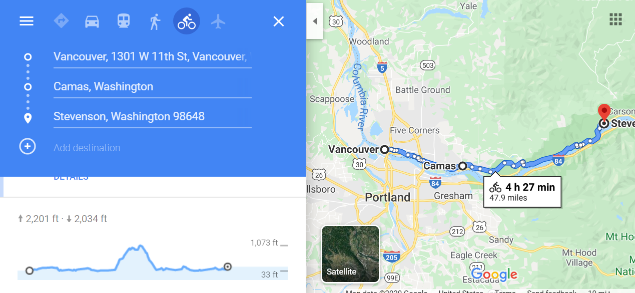
- Vancouver to Stevenson: 48.5 miles, +2,178 feet
- Camas, 15 miles: Coffee stop
- Skamania, 36 miles: Lunch stop
- Bridge of the Gods, 45 miles: Scenic stop
- Stevenson, 48.5 miles:
- Lodging options include fancy — could be fun to sleep in a treehouse at Skamania Lodge.
- Food: Lots of choices

- Stevenson to Lyle: 36 miles, +909 feet
- Bingen, 24 miles: Coffee stop; antique shop
- Lyle:
- Lodging options: Lyle Hotel
- Food: Sandbar & Grill; Country Cafe
- Attractions: Ride at least part of the Klickitat Rail-Trail — 31 miles if we do the entire loop, which includes some pavement but mostly gravel.

- Lyle to Biggs Junction, OR: 28 miles, +1204 feet, short-mileage day due to the amount of sightseeing (and sipping)
- Columbia Hills State Park, 10 miles: Take a two-mile side trip from the highway and walk to see “She Who Watches” petroglyphs
- Maryhill Winery, 21.5 miles: Lunch, tasting, purchasing, shipping a case of wine home….
- Maryhill Art Museum, 23 miles: Just a little past the winery on the highway
- Stonehenge Memorial, 27 miles: Just a little past the art museum and close to our stop for the night; I remember visiting this as a kid on a family vacation.
- Biggs Junction:
- Lodgings: Three Rivers Inn with continental breakfast
- Food: Best bet is likely the Flying J Truck Stop, which has PJ Fresh Market. There’s a BBQ pit with no online menu and I’m a vegetarian so I don’t assume I can eat there beyond maybe some fries. That’s not fuel.

Different option for the overnight stay: From Stonehenge ride 11 miles, +1165 feet, to Goldendale and visit the Goldendale Observatory that night, then backtrack to continue in the Gorge the next day. The observatory’s major capital reconstruction project will be open by June. This would let us buy food to carry with us for the next day, which might be a good idea given limitations in the next stretch. It makes for a very long day, though, to reach the only lodgings I could find in the next leg.
- Biggs to Not-Quite-Prosser: Alexandria Nicole Cellars Tiny Houses, 58 miles, +1211 feet (add another 11 miles if we stay in Goldendale — ouch)
- Lodgings: The tiny houses are the only lodgings I can find within striking distance of the Gorge to break up this stretch. Thus everything hinges on being able to book a stay here and on carrying our own food because it’s nowhere near any restaurants or grocery stores. I checked AirBnb and VRBO, both of which sometimes open up more options than commercial lodgings. Nothing.
- On WA side of the Columbia at Maryhill State Park, Gunkel Orchards/Fruit Stand is open 8am-6pm; cherries, apricots, peaches, nectarines. We’d be sorry if we over-indulged but this would be some thirst-quenching snacks for the road.
- Roosevelt, 35 miles: Lunch and groceries. The only available food stop in this stretch is Columbia River Country Store. Right at the top of its website it reads “Commonly known as ‘that little oasis’ by the fields of cyclists that come in.” Yep, it would be that for sure and certain. This is where we need to eat lunch and stock up for dinner + breakfast the next day; as they note on the site there’s no food for 35 miles in either direction. Fortunately, they’re open seven days a week.
- Alexandria Nicole Cellars, another 23 miles on for a total of 58 miles (from Biggs Junction) to ~70 (from Goldendale)

- Alexandria Nicole Cellars to Umatilla, OR: 31 miles, +335 feet; shorter day because Umatilla has more food options than the next available stop in Touchet
- Lodgings: Lamplighter Hotel, Umatilla Inn & Suites, Quality Inn, Econo Lodge
- Food: Grocery store, taco places (I can always find vegetarian options in Mexican/Latin American places), Rae’s Dayz Diner & Cakery, hot dog place that may only offer meat dogs, BBQ place

- Umatilla to Touchet, 40 miles, or keep going to Walla Walla, ~63 miles total
- Touchet:
- Lodgings: Super fancy Cameo Mansion sounds amazing, with price tag to match, or an AirBnB in a home in wine country that sounds peaceful and includes a light breakfast
- Food: One restaurant nearby, the Seedhouse Saloon. Can buy food in Umatilla and carry with us. Possible option: Cameo Mansion offers a car service to pick you up and return you, so if we want a 7-course meal in an amazing setting we could give our legs a break.
- Walla Walla
- Lodgings: Plenty in Walla Walla
- Food: Plenty of options in Walla Walla
- Attractions: Tasting rooms in downtown Walla Walla; ride southwest a bit along a bike trail to Fort Walla Walla Museum www.fwwm.org
- References: Umatilla to Dayton and the Cycling Sojourner “Walla Walla Wine Ramble” chapter
- Options: Light day Touchet to Walla Walla (20 miles, +587 feet), stay there, then Dayton the next day; or go Touchet to Dayton in one day (45 miles, +1608 feet); or ride Walla Walla to Dayton (31 miles, +1204 feet) if we pushed to Walla Walla from Umatilla.
- Touchet:

- Walla Walla to Dayton: 31 miles, +1204 feet, making use of the Middle Waitsburg Road as recommended in Cycling Sojourner
- Monteillet Fromagerie, 28 miles: Satisfy the inner turophile (lover of cheese) close to Dayton
- Lodgings: Weinhard Hotel (temporarily closed so this is a question mark), several other options including The Purple House B&B, Best Western, local motel
- Attractions: Antiques mall next door to the Weinhard; Liberty Theater might be showing something or have an event; Wenaha Gallery

And here we have a decision to make — head more towards the Idaho border and climb the old Spiral Highway (site of many a carsick memory of my childhood since I was born in Lewiston), see more Channeled Scablands than Palouse Country, or do a bit of a mix. Any of these routes involves a hot, dry ride with few services, really small towns and limited choices. Yet another option would be to head back west 58 miles to Tri-Cities and take Amtrak back from there but I’m trying to get to Spokane so we can visit friends and family at the end.
Related Posts
 Bike Tour Planning: (Relationship) Lessons Learned So Far
 Bike Touring Northwest Washington State: How Our Bike + Ferry + Train Loop Worked Out
 Bike Touring Round-up: Bike the Gap + C&O Canal Towpath
 Travel Takeaways: Policy Ponderings from a Long Bike Tour
 Travel Takeaways: Mental Musings from a Long Bike Tour
 Travel Takeaways: Physical Effects from a Long Bike Tour
 Washington Counties Challenge: A Statewide Bikespedition To-Do List
 Trails in Washington State: A Bikespedition Goal

Reader Comments