“It is by riding a bicycle that you learn the contours of a country best, since you have to sweat up the hills and can coast down them…. Thus you remember them as they actually are, while in a motorcar only a high hill impresses you, and you have no such accurate remembrance of country you have driven through as you gain by riding a bicycle.”
— Ernest Hemingway
“Papa” must have ridden in the Olympic Peninsula, since today certainly involved sweating up hills and coasting down them. With a mix of highway shoulders, side roads, and trails we covered 53 miles over the course of the day.
We started off right with a solid breakfast at The Cup in Port Townsend, which was hopping. Our substantial breakfasts were more than we could eat so we packed the leftovers for later. Fueled by calories, you know.
The first bit of our map was on State Route 20 heading out of Port Townsend. We cut over to South Discovery Road and had a much quieter experience there. Compared with Whidbey Island I didn’t see as many considerate people leaving extra space as they overtook us, but it was bearable.
We did have our one and only (to date) outright bad moment due to a driver’s bad decisions. A white woman in a station wagon came up to a stop sign on her side road, hesitated a tiny bit when her car was already past the stop bar, didn”t take a good look at oncoming traffic, and absolutely rolled right through the stop to make a left turn as we entered the intersection. I was in front yelling “Hey!” while Hubs bellowed “STOP SIGN!” from behind me. Since her window was down she should have heard us but it sure didn”t make her slam on the brakes.
[Policy sidebar: This is where I refer you to the 2015 National Motor Vehicle Crash Causation Survey by the National Highway Traffic Safety Administration (PDF) and tell you that in a study of tens of thousands of crashes researchers found that the critical reason — the last thing in the crash causal chain — in 94% of all crashes is driver error (attention, decision, or recognition error).
Sit with that a minute. Ninety-four percent of all crashes have driver error as the last thing before impact. Okay, policy sidebar over.]

As we rode away up the hill, glad she didn’t hit the gas a little harder or turn a little more sharply and end our vacation right there, I muttered, “A couple of cups of coffee, a couple of cups of adrenaline, and we’re on our way.”
Not far up the road We took a chance on a small stretch of the Larry Scott Trail, which is a portion of the Pacific Northwest Trail. I say “took a chance” because we have relatively skinny tires and this is a packed dirt trail. It felt a bit bumpy but was generally fine. We’ve had pretty dry weather recently and I wouldn”t try this with skinny tires if it had been raining much. It was nice to be in the woods but my guess is that staying on South Discovery Road would have worked fine.
And then it was highway time through Discovery Bay. I had been told to expect “zero shoulders”, but thanks to a Google Map of the Olympic Discovery Trail created by Andy Stephenson, former board member of the Peninsula Trails Coalition, I had a bit more nuanced information than that. Andy recorded shoulder widths on a color-coded map so I knew we would have some stretches of 1-2 feet, some of 4-5. (The ODT overall makes use of highway shoulders, side roads, and separated sections, and a dedicated bunch of commuters and transportation planners are all collaborating to complete it.)
Now, a couple of feet isn”t a full bike lane but it also isn”t zero shoulder. I think of zero as the stretches where the pavement ends with the edge of the fog line. I was anticipating that I’d be dueling with logging truck drivers for a toehold and that wasn’t the case. This was highway traffic at highway speeds and certainly wouldn’t work for everyone but we had a shoulder.
Don’t get me wrong. I would much rather ride on a wider shoulder with more separation if I have to be on a highway, would rather be on a side road than a highway anyway, and will take a traill connection even if it adds some extra distance if it means missing all the traffic and getting to relax. (Bear in mind that I’m on vacation so extra trail miles won’t mean being late to work the way they might for someone else.)
We climbed SR 20 for what felt like two miles — mostly because it was two miles. But then guess what? We got to coast down the other side for just as far! It goes by a lot faster on the downhill than on the uphill.
The shoulders were nice and clean — thanks, WSDOT Olympic Region Maintenance crews! With one small exception….
We had our first mechanical issue of the trip, with Hubs picking up a nail in his rear tire. Fortunately the timing let us stop at the Wild Birds Unlimited shop in Gardiner, which has an outside Porta Potty (not accessible design, however) and kind staff who will fill your water bottles for you.
And we had only a little more distance, most of it quiet miles on the Old Blyn Highway that felt all but deserted, before we could get onto the separated Olympic Discovery Trail [insert angelic chorus here].

Once on the ODT we rode through a mix of trail miles near the highway, woodsy miles, Sequim Bay State Park, some suburban streets in Sequim (with a stop at a playfield to sit a bit when I just needed to stop turning pedals for a few minutes), and a couple of in-town stretches where it was faster to take the street because the trail is popular — it goes on and on.
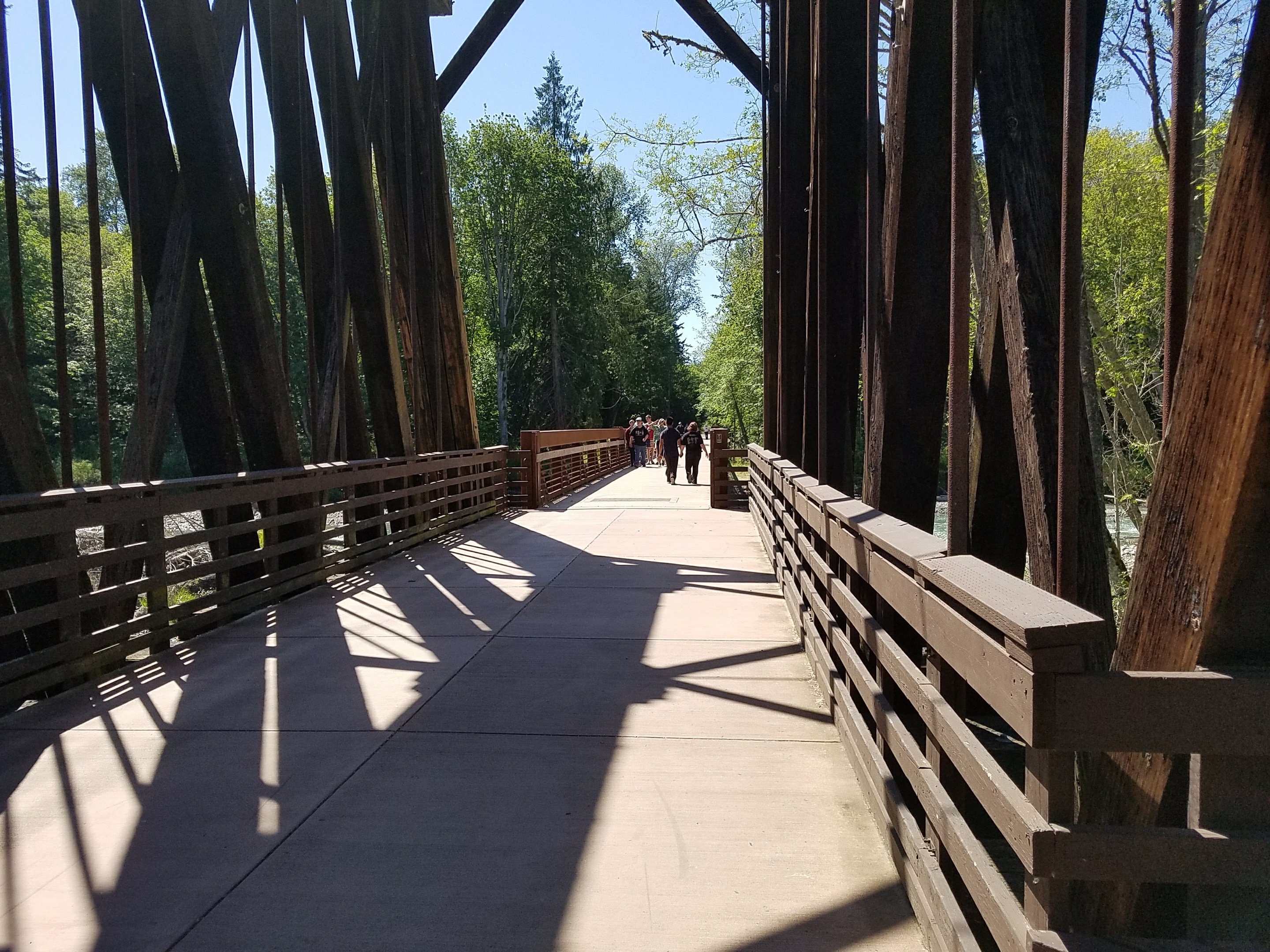
A discussion of the trail isn’t complete without mention of the striking trestles and bridges you get to cross. They’re simply beautiful.


We saw such a mix of people and bikes! Recumbents, a couple of three-wheelers with windscreens, kids on bikes, people of all shapes and sizes going whatever speed suits them, joggers, people walking dogs, a few horseback riders. A trail is a community, and a friendly one, with people cheerfully communicating to manage interactions.

One particular friend caught my tweet about the flat and got out onto the trail to meet us, so I got a great chance to chat with Ian Mackay, he of the big journey in his electric wheelchair from Port Angeles to Portland who delivered a keynote address at the 2017 Washington Bike Summit. He’s planning another trip, this one east to west from Coeur d”Alene to Seattle, so watch for a blog post to enlist people to help with his route plannin.
At the point where I saw Ian he told me we had about another four miles that involved hills and then it was a breeze to Port Angeles. He should know — he’s been on the trail every single day for something like 589 days in a row (or thereabouts — he thinks it’s around there). He was right about the hills, a couple of which had me pushing the bike.
He was also right about the breeze. After so many miles in deep woods, when we emerged onto the coast with the wind sweeping in from the Pacific Ocean and waves crashing, it pretty literally blew us away. It wasn’t long before we stopped to put on more layers; that was one brisk breeze.


The trail was almost entirely flat, though, and we cruised along. We skirted one deep puddle cautiously — a bit of a pond where it looked as if some of the hillside had changed position and they’re dealing with it. And then it was time to exit the trail on a climb up to a city street to find our lodgings for the night.
Distance: 53.1 miles
Total mileage to date:
Bike: 133.25 miles
Ferry: 9.7 miles
Wildlife: One deer, one eagle circling over the park where we rested, plenty of birdsong and chipmunks along the trail
Yesterday: Mukilteo to Port Townsend
Tomorrow: An easier day by far — heading to Lake Crescent for a couple of days of rest before coming back to Port Angeles and catching the ferry to Victoria
Note for route planning: You could easily break this into two days with an overnight in Sequim.
The Whole Trip
- On the Road Again: Getting Ready for a Washington State Bike + Ferry + Train Vacation
- Day One: Southwest Seattle to Mukilteo
- Day Two: Mukilteo to Port Townsend
- Day Three: Port Townsend to Port Angeles
- Day Four: Port Angeles to Lake Crescent
- Days Five and Six: Lake Crescent to Victoria, BC
- Days Seven and Eight: Victoria, BC to Friday Harbor
- Days Nine and Ten: Friday Harbor to Lopez Island
- Day Eleven: Lopez Island, a Gentle Retreat
- Day Twelve: Lopez Island to Anacortes
- Day Thirteen and Done: Anacortes to Southwest Seattle
- Bike Touring Northwest Washington: How Our Bike + Ferry + Train Loop Worked Out
- Bike Touring Planning (Relationship) Lessons Learned So Far
Related Posts
 On the Road Again: Getting Ready for a Washington State Bike + Ferry + Train Vacation
 Day One: Southwest Seattle to Mukilteo
 Day Two: Mukilteo to Port Townsend
 Washington Counties Challenge: A Statewide Bikespedition To-Do List
 Bike Touring Round-up: Bike the Gap + C&O Canal Towpath
 Travel Takeaways: Policy Ponderings from a Long Bike Tour
 Travel Takeaways: Mental Musings from a Long Bike Tour
 Wheeling Sea to Sound, Day Three

Reader Comments